Sunday 16 February 2020


Wayanad holiday trip and options

1)  Night Camping With Campfire In Wayanad

2) Night Camping with Campfire in Wayanad

3)Wayanad Photography Tour

About the activity :

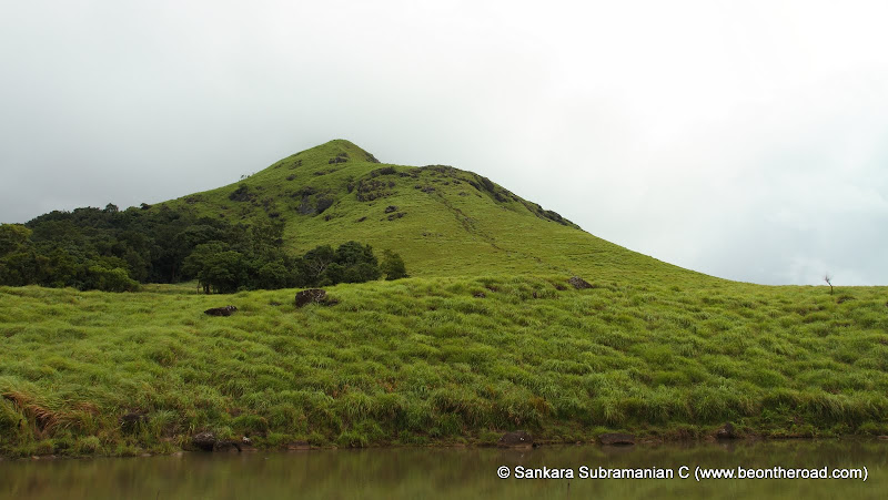
Photographers, what are your weekend plans? Well, now you have something exciting and happening to do and that too, with the best of plans! Enjoy an exciting Wayanad photography tour with your friends and family and revel in the fun with your camera clicking away! You can explore the world of reptiles and several amphibians while on this tour! Wildlife photographers, get your weapons ready! You will get a golden chance to rediscover some of the most unique species of reptiles, the different habitats and the unique colours and hues on the insects you discover here.

You can click a few amazing photos of the amazing scenery along with the exotic wildlife that live here. You can also participate in an introductory class on nature photography and the proper usage of filters. While at the Wayanad photography tour, you can also try your hand at slow shutter speed photography whilst capturing waterfalls.  Embark on a fun night walk with nature and hold your cameras close to you for the best shot!

Meal Types: All meals included

Transportation : Included

Accommodation : Included

Activities: Photography Tour, Nature Walk, Wildlife and Nature Experience

Difficulty Level: Easy

Show more
Things To Carry
7
Rain protection (poncho/jacket, umbrella, raincover for camera)
7
Shoes with good grip, preferably waterresistant (gum boots are optional but nosandals or flip-flops)
7
Flashlight with extra batteries
7
Leech socks
7
Binocular
7
Camera gear
7
Sun-screen, mosquito repellent (if preferred), handsanitizers and a whistle in case of emergency
7
First aid kit,Personal Medications (if preferred)
7
Covers /packing material for photographyequipment, rain-proof jackets – in case of light rains
Show more
Advisory
7
Dull coloured clothes (olive green, brown, grey)
7
Kindly do not play loud music during your stay
7
Refrain from littering the premises.
7

Spotting wildlife depends on weather conditions.Clear weather is favorable to watch birds whereas rains trigger more activityamongst amphibians, snakes and insects, making it easier for photographers tosee.

Friday 14 December 2012

Stay in Kalpetta - Wayanad

Best homestay in Wayanad 
Call : 9947147496 
Tearoute holiday home provides best hospitality for family and groups of students. 

Tuesday 11 December 2012

Ambukuthi Mala Wayanad


Ambukuthimala or Edakkalmala is one of the principal hills of the Wayanad District. The cave and 50 cents of land is taken over by the department and declared as protected Monument on 04-07-1985.
Edakkal Caves are two natural caves located 1000 metres above sea level on Ambukutty Mala 25 km from Kalpetta in the Wayanad district of Kerala in India's Western Ghats. They lie besides an ancient trade route connecting the high mountains of Mysore to the ports of Malabar coast. Inside the caves are pictorial writings believed to be from neolithic man indicating the presence of a prehistoric civilisation or rather settlement in this region. The stone age carvings of Edakkal are rare and are the only known examples from south India.The fascinating prehistoric rock etchings found on the walls of these caves have drawn the serious attention of archeologists and historians worldwide.
[Click on the images to enlarge]

The name "Edakkal" literally means "a stone in between", and this describes how the cave is formed by a heavy boulder straddling a fissure in the rock. Inside the cave is on two levels, the lower chamber measures about 18 feet long by 12 feet wide and 10 feet high and can be entered through an opening of 5 x 4 feet. A passage opposite the entrance leads upward to a small aperture in the roof through which one climbs up to the next storey whose interior is about 96 feet long, 22 feet wide, and 18 feet high. Light enters the cave through a big gap at the right-hand corner of the roof where the boulder does not touch the facing wall.

These are not technically caves but rather a cleft or rift approximately 96 feet by 22 feet, a 30 foot deep fissure caused by a piece of rock splitting away from the main body. On one side of the cleft is a rock weighing several tons that covers this cleft to form the 'roof' of the cave. The carvings are of human and animal figures, tools used by humans and of symbols yet to be deciphered, suggesting the presence of a prehistoric settlement.The petroglyphs inside the cave are of at least three distinct types. The oldest may date back to over 8000 years. Evidences suggest that the Edakkal caves were inhabited several times at different points in history.The caves were accidentally discovered by Fred Fawcett, a police official of the erstwhile Malabar state in 1890 who immediately recognised their anthropological and historical importance. He subsequently wrote an article about them, attracting the attention of scholars worldwide.

The walls on both sides of the Edakkal rock shelter are embroidered up to a height of over four meters, and down below the present floor level of the cave with deeply carved motifs and signs which look particularly dramatic in the cool, mellow sheen of the damp interior. The rock surface is chock-full of linear motifs most of which form a vertically carved jumble of deep incisions so congested that they are uncountable, a baffling magic of lines in the midst of which many weird-shaped figures seem to be emerging and disappearing, their forms melding and changing in different lights. We can identify crosses, triangles and tridents; squares, some with inner crosses, and a rectangle divided into nine square-shaped chambers; stars, wheels and quatrefoils; spirals, whorls and volutes; plant motifs, pot-shaped items; various animals including ones resembling foxes, dogs and dear; and the unmistakable outline of an elephant.
There are many human figures. A good number of the men have raised hair, of these the most elegant is the figure of a man whose left hand is unnaturally long and reaching his feet. He holds an angular object in his right hand and seems to be wearing a tight garment that reveals an hour-glass torso. Another man has a square-shaped head and spiral belly. Some of the figures are wearing masks and heavy garments. The figure of a woman is easily recognizable, her head is simplified into a cross, and another cross is marked on her hips, there is another, nicely drawn figure of a woman shown standing on a platform. The most eye-catching and somewhat formidable human figure is a life-size male shown standing in frontal pose with raised arms and hair. His face, probably masked, is at a height of the eye-level of the viewer, thus it seems as if he is hindering the entry of outsiders.
We are from photographs taken just 100 years ago that the present floor of the cave is some 40 centimetres higher it used to be, thus the man below his knees is today buried in the soil, and his face which is now at eye-level, once looked down on the viewer. These are just some examples of the many forms and figures that decorate the Edakkal cave. As far as we can tell, they were probably created during the Neolithic period of the Late Stone Age and date from about 1000BC. In addition to the pictorial carvings, five ancient inscriptions have been identified of which two have been deciphered.


Edakkal Cave

Legends about Edakkal Caves

The name Ambukuthimala is ascribed to the local legend which has it that the caves were formed by arrows fired by Lava and Kusha, the sons of Sri Rama, legendary hero of the Ramayana.Even today there are many who believe that Lord Rama killed Surpanakha, the sister of Ravana, in the narrow fissure at the southern end of Edakkal cave.

A local legend associates Kutti Chatan (the little devil of Malabar) with the goddess Mudiampilli, and until recently local people undertook an annual pilgrimage to the peak of the hill to perform a puja (ritual offering) in her honour.

Cave at Edakkal Location:

Village - Nenmeni, Taluk - Sultan Betheri, District - Wayanad, Location - About 3kms from Ambalavayal in Ambalavayal - Kalpatta route.
To reach the Edakkal caves from Tellicherry take the following shortest bus route: Tellicherry > Koothuparamba > Mananthavady > Get down at Beenachi on the way to Sultanbathery > Take Ambalavayal route > Get down at Ayiramkolli > Take bus to Edakkal caves.
Approximate time required to climb till top of the hill and down: 3รข€“4 hours. Entry to the hill closes by 4 PM.
Departmental jeeps can be hired to travel the initial few km till the foot of the hill. A jeep can carry up to six passengers and there are separate rates for one way and return journeys.

Other nearby places:

Soojippara water falls, Sultan Bathery, Mutanga Wildlife Sanctuary.

Chennai (Tamil Nadu) to Wayanad Time by Road


Chennai (Tamil Nadu) to Wayanad (Kerala)

 is 

589 km.


Time by road is 

13 hrs.

589
Wayanad houses no airport as well as rail station. The nearest airport connecting to Chennai is Karipur International airport at Kozhikode. Regular flights connect Karipur and Chennai. To reach Wayanad, one can avail taxi from the airport which cost around Rs 2,000.

The closest railhead connecting to Chennai is Kozhikode (CLT) and from the station taxis can be hired for Wayanad which charges about Rs 1,000. Public bus services are also available with a cost around Rs 57. 

Deluxe buses can be another option to reach Wayanad from Chennai. Besides, one can also hire a taxi which will cost within Rs 11,000 to Rs 16,500 (for a round trip).

Chennai to Wayanad Trains

From
To
Depart (dd/mm/yyyy)
 
No. of passengers
Also search on (opens new window)
 Yatra   
Wayanad does not have railway station. Palakkad (PGT), Coimbatore Jn (CBE), Kozhikkode (CLT) and Mysore Jn (MYS) are 4 nearby train stations connected to Chennai. 
Chennai to Kozhikode Trains
  
 
Trains to Kozhikode depart from 2 stations in Chennai: Chennai Egmore (MS) and Chennai Central (MAS)
  
 
Related: Kozhikode to Wayanad
NoTrainDepartureArrivalDurationRunning Days
1West Coast Exp
(16627)
11:30 AM
(Chennai Central)
11:50 PM
(Kozhikkode)
12h 20mAll Days 
2Mangalore Exp
(12685)
05:00 PM
(Chennai Central)
04:15 AM
(Kozhikkode)
11h 15mMon, Wed, Thu, Fri, Sat & Sun 
3Mangalore Mail
(12601)
08:25 PM
(Chennai Central)
07:50 AM
(Kozhikkode)
11h 25mAll Days 
4Ms Mangalore Ex
(16107)
10:15 PM
(Chennai Egmore)
04:55 PM
(Kozhikkode)
18h 40mAll Days 
See All 
Note: The running days are from Chennai.
Chennai to Coimbatore Trains
  
 
Trains to Coimbatore depart from 2 stations in Chennai: Chennai Egmore (MS) and Chennai Central (MAS)
  
 
Related: Coimbatore to Wayanad
NoTrainDepartureArrivalDurationRunning Days
1Tata Allp Exp
(18189)
03:25 AM
(Chennai Central)
12:05 PM
(Coimbatore Jn)
8h 40mAll Days 
2Dhn Alappuzha E
(13351)
03:25 AM
(Chennai Central)
12:05 PM
(Coimbatore Jn)
8h 40mAll Days 
3Pnbe Ers Expres
(16310)
04:15 AM
(Chennai Central)
12:35 PM
(Coimbatore Jn)
8h 20mSat & Sun 
4Shm Tvc Express
(16324)
04:15 AM
(Chennai Central)
12:35 PM
(Coimbatore Jn)
8h 20mTue & Thu 
5Ghy Tvc Express
(12516)
04:40 AM
(Chennai Central)
01:15 PM
(Coimbatore Jn)
8h 35mFri 
See All 
Note: The running days are from Chennai.
Chennai to Mysore Trains
  
 
Trains to Mysore depart from 1 station in Chennai: Chennai Central (MAS)
  
 
Related: Mysore to Wayanad
NoTrainDepartureArrivalDurationRunning Days
1Shatabdi Exp
(12007)
06:00 AM
(Chennai Central)
01:00 PM
(Mysore Jn)
7hMon, Tue, Thu, Fri, Sat & Sun 
2Mysore Express
(16222)
09:30 PM
(Chennai Central)
07:40 AM
(Mysore Jn)
10h 10mAll Days 
3Mysore Express
(22682)
11:30 PM
(Chennai Central)
08:35 AM
(Mysore Jn)
9

Chembra Peak Wayanad - Help articles for Trekking tourist


Monsoon Trek to Chembra Peak, Wayanad, Kerala, India

 
A tropical trek in the monsoons is just what the doctor ordered. And it gets even better if the trek is in theWestern Ghats, which is one of the hottest bio-diversity hotspots in the world. 

 
Such a tropical trek in the monsoons is the best way to relax one’s soul amidst a world that is dressed in fresh green. This time the destination was Chembra Peak, the highest peak in the district of Wayanad (Wynad) in Kerala

  
My friends (Vishwadeep Anshu and Anand Sharma) and I left Bangalore at 5 am on a Saturday morning to reach Meppady six hours later. 

 
The route we took was Bangalore –> Mysore –> Gundlupet –> Kalpetta –> Meppady. The total distance to Meppady from Bangalore is about 320 kms. 

 
From Meppady, we drove through tea estates to reach Chembra estate where the forest office is located. It was here at the forest office that we bought trekking permits, camera permits and hired the services of a forest trekking guide. 

 
The trekking permit for a group of 10 people costs 500 rupees. This includes the services of a forest trekking guide. Still cameras are charged at 25 rupees. Video cameras are not allowed on the trek. 

 
After getting the necessary permits, we drove to the point, which was the start of the trek. We parked our car, got introduced to our trekking guide, Srinivasan, wore our trekking shoes and began the trek. 

 
The first 300 metres of the trek was a pretty straight forward walk that passes through tea estates on both sides. After these 300 metres, we had to take a left turn that climbs steeply through lush green grasslands. 

 
From this left turn onwards, it is a straight and steep climb. There is a clear trail that winds its way upwards. 

 
The first thirty minutes of the trail passes through evergreen forests, but the vegetation changes to grasslands with increasing altitude. 

 
Once the surroundings change into grasslands, it stays as grasslands right up to the top. The climb is slightly tough and we took some short breaks to catch our breath and to rehydrate ourselves. 


After an hour of climbing, we came across a water body, which is called the first lake. From here, we ascended further for another 30 minutes before we reached a heart shaped lake, which is a scenic spot and a tourist attraction on this trek. 

 
We took a break at this lake, indulged in some photography and then continued with our trek. It took us another hour and a half to reach the Chembra peak. 


The final stretch is extremely rocky and slippery and one has to be careful to avoid the steep cliff on one side.

 
By the time we reached the top, it started drizzling and the mountain mist enveloped us. To avert any mishaps, we decided to descend to the next safest point, known as the view point. 


One can get great views of the Chembra peak and the surrounding evergreen forests and grasslands from here. 

  
We decided to settle here for a while, but unfortunately could not do so as the intensity of the rains began to increase. Thus, we began our descent in rain and in intermittent mist. 

 
While climbing, we were cursing the steep path, but only when did we descend, did we realize that the descent is tougher than the ascent. 

 
The slushy trail, the slippery rocks, the pelting rain and the poor visibility created the ideal concoction for a deadly descent. All of us slipped. I personally landed on my back-side four times. But, thankfully, none of us faced any injuries. 


The descent was extremely hurried as we were worried about more rain and thus losing visibility. And thus we descended back to the tea estate trail in about 2 hours. The ascent had taken us three and a half hours, including our small stops and long breaks. 

  
So, finally after five and a half hours, we had finished our monsoon trek to Chembra Peak. In spite of this being leech country and the monsoons, most of us surprising had only one or two leech bites. 

 
It was a heady feeling at the end of the trek. I guess all of us were intoxicated by the pure air and the lovely green surroundings. After the trek, we drove back to Meppady, found ourselves decent budget accommodation and settled in there to spend the night. 

-------------------------------------------------------------------------------------------


Chembra Peak we all knew was a goodspot for one day trekking. 290 kms away from Bangalore it stands tall amidst the green misty hills which is the tallest summit (2100 m) in Wayanad. On a thursday evening, amidst our discussion of conducting local treks to introduce new folks to trekking, it was decided that I set out that weekend and see what Chembra peak is all about. The time to plan was short. Two of us decided to hop into a bus heading in the direction of Wayanad on a Saturday night and take the rest as it came. We set out from Bangalore at 10 p.m on a Rajahamsa bus heading to Calicut. The journey was smooth and at 7.30a.m we got off at Kalpetta in the Wayanad district of Kerala.
From Kalpetta, the next destination is the small town of Meppadi which is half an hour away by bus. Buses ply from the bus stand at Kalpetta to Meppadi often. Get off at Meppad mosque and take an auto to reach the base of the trek. The distance to the base is about 7kms and the autos can charge you upto Rs.100 for the distance. A small road takes you through Fathima estates.
Chembra peak forest office

The forest office is 2kms inside from the main road. Get off at the office and take an entry ticket. The ticket is priced at Rs.500 for upto 10 people. Insist on a getting a guide at the forest office. The trek starts at the watch tower which is 5kms away from the forest office. If you are driving, there is a designated place for parking your vehicles. The drive to the watch tower takes you through beautiful rolling tea gardens. The gardens themselves are a treat to the eye. 

Chembra watch tower

At the watch tower, take the path going up and cross the tower. Veer towards your left and enter path taking you into the forest overgrowth. Its a moderate climb up and in half an hour you find yourself out of the forest cover. Enter the overgrown grassland area and the trail takes you up. There is not much of a chance to miss your path and just follow the trail.In half an hour you find yourself in a relatively flat area. You'll pass a small puddle on your right and so do not mistake it for the well known heart shaped lake of Chembra trek.

Another inclined climb for 15 minutes and you come to the heart shaped lake. It is easy to get mistaken that the peak is right in front of the lake but what you see from there is only the first of the 6 peaks to come.The final one is the tallest and your destination for the day. 
 
Chembra peak heart shaped lake

No confusing paths ahead, all you have to do is head up and keep reaching upto the higher peak. If you don't know the exact number of peaks you have to cover, you are always under the false hope that what you see ahead is the final one. Only to go there and find the next taller peak beckoning you. The trek from the lake to the peak takes two more hours. The lake is infact at about the mid point of the trek.
 Return from chembra trek 
The trek up should on the whole take about 4 hours for medium paced trekkers. Spend some time on the peak and on a clear day, the entire Waynad can be seen. Ask your guide to show you what is where. On a cloudy day, you can get engulfed in the clouds and the visibility may not be more than 100meters. Clouds can play hide and seek with you on this trek rather well.

chembrapeakslipperydescent

The descent can be a little slippery if you are there just after monsoon or during monsoon. It can require a good amount of your concentration to avoid any slips and falls. The descent can take about 3 to 4 hours. Once at the watch tower, you can wait a few minutes and in all probability find an auto which has just come up with people. The return fare is cheaper is about Rs.15 per head for the drop back to the main road.
The forest office is open on all days and you can go there and take permission for a day trek. Overnight camping on the hills is not allowed for the fear of lurking wild animals. The trek can very comfortably completed in a day and a fitting end to the trek would be a drive to the nearby Soochippara(sentinel rocks) water falls are 200 m (656 ft) in height and offers a cliff face that is good for rock climbing.