Monsoon Trek to Chembra Peak, Wayanad, Kerala, India
A tropical trek in the monsoons is just what the doctor ordered. And it gets even better if the trek is in theWestern Ghats, which is one of the hottest bio-diversity hotspots in the world.

Such a tropical trek in the monsoons is the best way to relax one’s soul amidst a world that is dressed in fresh green. This time the destination was Chembra Peak, the highest peak in the district of Wayanad (Wynad) in Kerala.

My friends (Vishwadeep Anshu and Anand Sharma) and I left Bangalore at 5 am on a Saturday morning to reach Meppady six hours later.

The route we took was Bangalore –> Mysore –> Gundlupet –> Kalpetta –> Meppady. The total distance to Meppady from Bangalore is about 320 kms.

From Meppady, we drove through tea estates to reach Chembra estate where the forest office is located. It was here at the forest office that we bought trekking permits, camera permits and hired the services of a forest trekking guide.

The trekking permit for a group of 10 people costs 500 rupees. This includes the services of a forest trekking guide. Still cameras are charged at 25 rupees. Video cameras are not allowed on the trek.

After getting the necessary permits, we drove to the point, which was the start of the trek. We parked our car, got introduced to our trekking guide, Srinivasan, wore our trekking shoes and began the trek.
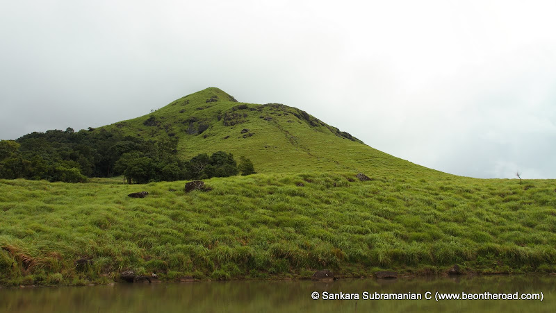
The first 300 metres of the trek was a pretty straight forward walk that passes through tea estates on both sides. After these 300 metres, we had to take a left turn that climbs steeply through lush green grasslands.

From this left turn onwards, it is a straight and steep climb. There is a clear trail that winds its way upwards.

The first thirty minutes of the trail passes through evergreen forests, but the vegetation changes to grasslands with increasing altitude.

Once the surroundings change into grasslands, it stays as grasslands right up to the top. The climb is slightly tough and we took some short breaks to catch our breath and to rehydrate ourselves.

After an hour of climbing, we came across a water body, which is called the first lake. From here, we ascended further for another 30 minutes before we reached a heart shaped lake, which is a scenic spot and a tourist attraction on this trek.

We took a break at this lake, indulged in some photography and then continued with our trek. It took us another hour and a half to reach the Chembra peak.

The final stretch is extremely rocky and slippery and one has to be careful to avoid the steep cliff on one side.

By the time we reached the top, it started drizzling and the mountain mist enveloped us. To avert any mishaps, we decided to descend to the next safest point, known as the view point.

One can get great views of the Chembra peak and the surrounding evergreen forests and grasslands from here.

We decided to settle here for a while, but unfortunately could not do so as the intensity of the rains began to increase. Thus, we began our descent in rain and in intermittent mist.

While climbing, we were cursing the steep path, but only when did we descend, did we realize that the descent is tougher than the ascent.

The slushy trail, the slippery rocks, the pelting rain and the poor visibility created the ideal concoction for a deadly descent. All of us slipped. I personally landed on my back-side four times. But, thankfully, none of us faced any injuries.

The descent was extremely hurried as we were worried about more rain and thus losing visibility. And thus we descended back to the tea estate trail in about 2 hours. The ascent had taken us three and a half hours, including our small stops and long breaks.

So, finally after five and a half hours, we had finished our monsoon trek to Chembra Peak. In spite of this being leech country and the monsoons, most of us surprising had only one or two leech bites.

It was a heady feeling at the end of the trek. I guess all of us were intoxicated by the pure air and the lovely green surroundings. After the trek, we drove back to Meppady, found ourselves decent budget accommodation and settled in there to spend the night.
Such a tropical trek in the monsoons is the best way to relax one’s soul amidst a world that is dressed in fresh green. This time the destination was Chembra Peak, the highest peak in the district of Wayanad (Wynad) in Kerala.
My friends (Vishwadeep Anshu and Anand Sharma) and I left Bangalore at 5 am on a Saturday morning to reach Meppady six hours later.
The route we took was Bangalore –> Mysore –> Gundlupet –> Kalpetta –> Meppady. The total distance to Meppady from Bangalore is about 320 kms.
From Meppady, we drove through tea estates to reach Chembra estate where the forest office is located. It was here at the forest office that we bought trekking permits, camera permits and hired the services of a forest trekking guide.
The trekking permit for a group of 10 people costs 500 rupees. This includes the services of a forest trekking guide. Still cameras are charged at 25 rupees. Video cameras are not allowed on the trek.
After getting the necessary permits, we drove to the point, which was the start of the trek. We parked our car, got introduced to our trekking guide, Srinivasan, wore our trekking shoes and began the trek.
The first 300 metres of the trek was a pretty straight forward walk that passes through tea estates on both sides. After these 300 metres, we had to take a left turn that climbs steeply through lush green grasslands.
From this left turn onwards, it is a straight and steep climb. There is a clear trail that winds its way upwards.
The first thirty minutes of the trail passes through evergreen forests, but the vegetation changes to grasslands with increasing altitude.
Once the surroundings change into grasslands, it stays as grasslands right up to the top. The climb is slightly tough and we took some short breaks to catch our breath and to rehydrate ourselves.
After an hour of climbing, we came across a water body, which is called the first lake. From here, we ascended further for another 30 minutes before we reached a heart shaped lake, which is a scenic spot and a tourist attraction on this trek.
We took a break at this lake, indulged in some photography and then continued with our trek. It took us another hour and a half to reach the Chembra peak.
The final stretch is extremely rocky and slippery and one has to be careful to avoid the steep cliff on one side.
By the time we reached the top, it started drizzling and the mountain mist enveloped us. To avert any mishaps, we decided to descend to the next safest point, known as the view point.
One can get great views of the Chembra peak and the surrounding evergreen forests and grasslands from here.
We decided to settle here for a while, but unfortunately could not do so as the intensity of the rains began to increase. Thus, we began our descent in rain and in intermittent mist.
While climbing, we were cursing the steep path, but only when did we descend, did we realize that the descent is tougher than the ascent.
The slushy trail, the slippery rocks, the pelting rain and the poor visibility created the ideal concoction for a deadly descent. All of us slipped. I personally landed on my back-side four times. But, thankfully, none of us faced any injuries.
The descent was extremely hurried as we were worried about more rain and thus losing visibility. And thus we descended back to the tea estate trail in about 2 hours. The ascent had taken us three and a half hours, including our small stops and long breaks.
So, finally after five and a half hours, we had finished our monsoon trek to Chembra Peak. In spite of this being leech country and the monsoons, most of us surprising had only one or two leech bites.
It was a heady feeling at the end of the trek. I guess all of us were intoxicated by the pure air and the lovely green surroundings. After the trek, we drove back to Meppady, found ourselves decent budget accommodation and settled in there to spend the night.
-------------------------------------------------------------------------------------------
Chembra Peak we all knew was a goodspot for one day trekking. 290 kms away from Bangalore it stands tall amidst the green misty hills which is the tallest summit (2100 m) in Wayanad. On a thursday evening, amidst our discussion of conducting local treks to introduce new folks to trekking, it was decided that I set out that weekend and see what Chembra peak is all about. The time to plan was short. Two of us decided to hop into a bus heading in the direction of Wayanad on a Saturday night and take the rest as it came. We set out from Bangalore at 10 p.m on a Rajahamsa bus heading to Calicut. The journey was smooth and at 7.30a.m we got off at Kalpetta in the Wayanad district of Kerala.
From Kalpetta, the next destination is the small town of Meppadi which is half an hour away by bus. Buses ply from the bus stand at Kalpetta to Meppadi often. Get off at Meppad mosque and take an auto to reach the base of the trek. The distance to the base is about 7kms and the autos can charge you upto Rs.100 for the distance. A small road takes you through Fathima estates.

The forest office is 2kms inside from the main road. Get off at the office and take an entry ticket. The ticket is priced at Rs.500 for upto 10 people. Insist on a getting a guide at the forest office. The trek starts at the watch tower which is 5kms away from the forest office. If you are driving, there is a designated place for parking your vehicles. The drive to the watch tower takes you through beautiful rolling tea gardens. The gardens themselves are a treat to the eye.

At the watch tower, take the path going up and cross the tower. Veer towards your left and enter path taking you into the forest overgrowth. Its a moderate climb up and in half an hour you find yourself out of the forest cover. Enter the overgrown grassland area and the trail takes you up. There is not much of a chance to miss your path and just follow the trail.In half an hour you find yourself in a relatively flat area. You'll pass a small puddle on your right and so do not mistake it for the well known heart shaped lake of Chembra trek.
Another inclined climb for 15 minutes and you come to the heart shaped lake. It is easy to get mistaken that the peak is right in front of the lake but what you see from there is only the first of the 6 peaks to come.The final one is the tallest and your destination for the day.

No confusing paths ahead, all you have to do is head up and keep reaching upto the higher peak. If you don't know the exact number of peaks you have to cover, you are always under the false hope that what you see ahead is the final one. Only to go there and find the next taller peak beckoning you. The trek from the lake to the peak takes two more hours. The lake is infact at about the mid point of the trek.

The trek up should on the whole take about 4 hours for medium paced trekkers. Spend some time on the peak and on a clear day, the entire Waynad can be seen. Ask your guide to show you what is where. On a cloudy day, you can get engulfed in the clouds and the visibility may not be more than 100meters. Clouds can play hide and seek with you on this trek rather well.

The descent can be a little slippery if you are there just after monsoon or during monsoon. It can require a good amount of your concentration to avoid any slips and falls. The descent can take about 3 to 4 hours. Once at the watch tower, you can wait a few minutes and in all probability find an auto which has just come up with people. The return fare is cheaper is about Rs.15 per head for the drop back to the main road.
The forest office is open on all days and you can go there and take permission for a day trek. Overnight camping on the hills is not allowed for the fear of lurking wild animals. The trek can very comfortably completed in a day and a fitting end to the trek would be a drive to the nearby Soochippara(sentinel rocks) water falls are 200 m (656 ft) in height and offers a cliff face that is good for rock climbing.
No comments:
Post a Comment